Jeostatik:
Kutupsal yörüngeli:
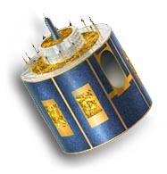
Meteosat Second Generation (MSG)

Meteosat-11: 0.°
Operatör: EUMETSAT
Yörünge tipi: Jeostatik
Enstrüman: SEVIRI (spinning enhanced visible and infrared imager)
Spektral bant sayısı: 12
Uydu altı noktasında çözünürlük: VIS/NIR: 1~3km, IR: 3km
Resimler 15 dakikalık zaman aralıkları ile alınır.
Avrupa görüntüleri her 5 dakikada bir alınır.

Meteosat-8: 41.5°E
Radyometre, dünya yüzeyini hatlar halinde tarar; her hat bir dizi tekil görüntü nesnesi veya pikselden oluşur. Her piksel için radyometre farklı spektral bantların ışın enerjisini ölçer. Bu ölçüm dijital olarak kodlanır ve kullanıcı topluluğuna dağıtılmadan önce ön-işleme için yer istasyonuna gönderilir.
Jeostatik:
Kutupsal yörüngeli: